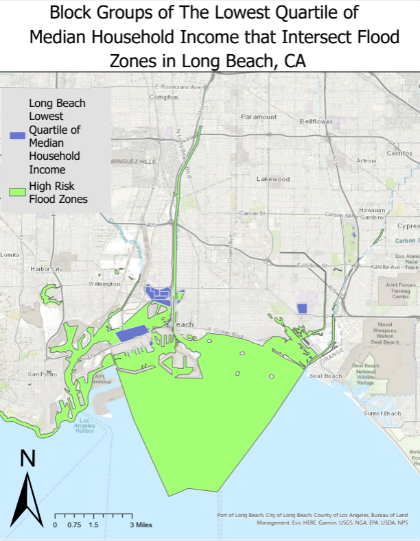
My interest in Geographic Information Systems (GIS) stems from its remarkable ability to address complex real-world challenges through spatial analysis and data visualization. During my academic tenure, I became deeply immersed in the capabilities of GIS, recognizing its potential to revolutionize problem-solving across various domains. From environmental conservation to urban planning, I see GIS as a catalyst for innovation and informed decision-making. This portfolio showcases my skills in interactive web mapping, geospatial programming, and data-driven analysis.
Work Experience
Mapping Analyst and Lidar Technician
Aerotas, LLC | 01/2025 – Current
Using Auto-CAD and CIVIL 3D to draft 3D linework on survey projects.
Processing 2D and 3D recreations of aerial data in DJI Terra and Pix4D.
Creating fully classified LiDAR point clouds using Global Mapper.
Creating survey grade digital elevation models (DEMs) from classified LiDAR.
As a personal project, I developed a Star Trek-themed arcade game from scratch using HTML, CSS, and JavaScript. All of the in-game assets, including the starships and projectiles, are custom SVGs that I designed and created myself.
Please note: This is still a work in progress, so you may encounter some bugs!